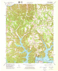
1978 Map of Frogue
USGS Topo · Published 1979About this map
The Cumberland River loops through the northern reaches of this landscape, while the sprawling fingers of Dale Hollow Lake dominate the south, creating a complex geography of ridges and flooded hollows. This 1970s survey captures a rural territory defined by small settlements like Frogue, Hegira, and Modoc, where life centered around country congregations such as Brannan Grove Ch and New Salem Ch. The influence of the petroleum industry is evident in the numerous Oil Wells scattered across the ridges, particularly near Kettle and Sexton Fork. Along the shores of the reservoir, Dale Hollow Lake State Park preserves the peninsula between Mill Creek and Illwill Creek, featuring a dedicated Picnic Area and Campgrounds. Genealogists will find significant value in the documentation of family-named landmarks and burial sites, including Groce Cem and Long Cem.
Find a feature on this map
57 named features on this map. Tap any name to fly to it.
Don’t see what you’re looking for? This feature index may not catch every label — zoom into the map to look around manually.
Map Details
Editions of this 1978 Frogue Map
2 editions found
Other maps of this area

1924 · Lillydale
USGS Topo · 1:62,500

1926 · Lillydale
USGS Topo · 1:62,500

1929 · Lillydale
USGS Topo · 1:62,500

1929 · Byrdstown
USGS Topo · 1:62,500

1953 · Waterview
USGS Topo · 1:24,000

1953 · Burkesville
USGS Topo · 1:24,000

1953 · Wolf Creek Dam
USGS Topo · 1:24,000

1954 · Frogue
USGS Topo · 1:24,000

1954 · Blacks Ferry
USGS Topo · 1:24,000

1954 · Albany
USGS Topo · 1:24,000