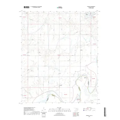
2018 Map of Frogville
USGS Topo · Published 2018About this map
The Kiamichi River flows south toward its confluence with the Red River, defining a landscape of riparian lowlands and agricultural plateaus along the Oklahoma-Texas border. This 2018 survey reveals the dispersed settlement patterns of southeastern Choctaw County, anchored by the community of Fort Towson in the north and the small hamlet of Frogville further south. The area is marked by a high concentration of burial sites reflecting family and community history, including the Everidge Cem, Spring Hill Cem, and the Missionary Cem located near Goodwater Cr. Along the winding path of the Red River, significant hydrological features like the Everidge Lake Cut-off and Bowman Island illustrate the shifting nature of the state boundary. Local water management is represented by the Frogville Cr Site 2 Reservoir, while smaller tributaries like Sandy Br and Gates Cr drain the surrounding timber and pasture lands.
Find a feature on this map
46 named features on this map. Tap any name to fly to it.
Don’t see what you’re looking for? This feature index may not catch every label — zoom into the map to look around manually.
Map Details
Editions of this 2018 Frogville Map
This is the sole edition of this map. No revisions or reprints were ever made.
Other maps of this area

1901 · Alikchi
USGS Topo · 1:125,000

1950 · Mcalester
USGS Topo · 1:250,000

1951 · Slate Shoals
USGS Topo · 1:24,000

1951 · Frogville
USGS Topo · 1:24,000

1951 · Shoals
USGS Topo · 1:24,000

1951 · Kiomatia
USGS Topo · 1:24,000

1951 · Woodland
USGS Topo · 1:24,000

1951 · Manchester
USGS Topo · 1:24,000

1953 · Texarkana
USGS Topo · 1:250,000

1956 · Texarkana
USGS Topo · 1:250,000