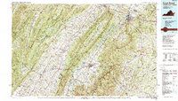
1986 Map of Front Royal
USGS Topo · Published 1989About this map
Massanutten Mountain and the high ridges of the Blue Ridge dominate this mid-1980s landscape, framing the agricultural and industrial corridors of the Shenandoah Valley. The serpentines of the South Fork Shenandoah River wind through the valley floor, connecting historic centers like Luray and Front Royal. This period of the valley's history is marked by the presence of significant infrastructure, including the Southern Railway and Norfolk and Western Railway, which parallel the older turnpike routes of U.S. 11 and the modern I-81. Within Shenandoah National Park, the winding course of Skyline Drive provides access to prominent peaks such as Hawksbill and Stony Man, while the western portion of the map shows the complex ridges of the George Washington National Forest and the Virginia - West Virginia State Line.
Find a feature on this map
186 named features on this map. Tap any name to fly to it.
Don’t see what you’re looking for? This feature index may not catch every label — zoom into the map to look around manually.
Map Details
Editions of this 1986 Front Royal Map
3 editions found
Other maps of this area

1884 · Harpers Ferry
USGS Topo · 1:125,000

1887 · Spottsylvania
USGS Topo · 1:125,000

1891 · Harpers Ferry
USGS Topo · 1:125,000

1891 · Romney
USGS Topo · 1:125,000

1892 · Spottsylvania
USGS Topo · 1:125,000

1892 · Franklin
USGS Topo · 1:125,000

1892 · Woodstock
USGS Topo · 1:125,000

1892 · Gordonsville
USGS Topo · 1:125,000

1892 · Harrisonburg
USGS Topo · 1:125,000

1893 · Luray
USGS Topo · 1:125,000