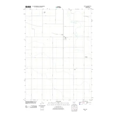
2010 Map of Frost
USGS Topo · Published 2010About this map
Frost serves as the central hub of this agricultural landscape in Faribault County, anchored by the Frost Post Office and a grid of numbered roads. The terrain is defined by the winding course of the East Branch Blue Earth River and engineered waterways like County Ditch Number Fiftyfive, which support the intensive farming characteristic of southern Minnesota. Genealogical interest is particularly high here, with several significant burial grounds documented across the township, including Bethany Cemetery, Emerald Cemetery, and the South Blue Earth Lutheran Cemetery. In the northern section, Schaper Landing Strip and the small settlement of Dell reflect the local transportation and community nodes. The map captures a moment in the 21st century where the traditional rural structure remains remarkably intact, showing the relationship between early 20th-century church settlements and modern infrastructure.
Find a feature on this map
25 named features on this map. Tap any name to fly to it.
Don’t see what you’re looking for? This feature index may not catch every label — zoom into the map to look around manually.
Map Details
Editions of this 2010 Frost Map
This is the sole edition of this map. No revisions or reprints were ever made.
Other maps of this area

1954 · Fairmont
USGS Topo · 1:250,000

1954 · Mason City
USGS Topo · 1:250,000

1955 · Bricelyn
USGS Topo · 1:62,500

1957 · Mason City
USGS Topo · 1:250,000

1958 · Mason City
USGS Topo · 1:250,000

1958 · Fairmont
USGS Topo · 1:250,000

1967 · Elmore
USGS Topo · 1:24,000
1967 · Blue Earth
USGS Topo · 1:24,000

1972 · Buffalo Center
USGS Topo · 1:24,000

1972 · Buffalo Center NE
USGS Topo · 1:24,000