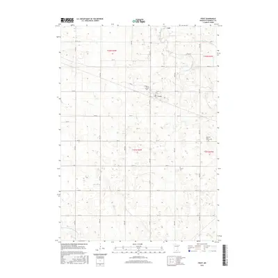
2016 Map of Frost
USGS Topo · Published 2016About this map
Frost and the smaller settlement of Dell anchor this agricultural landscape in southern Minnesota, defined by the systematic drainage and irrigation of the prairie. The region is marked by significant engineering of the local hydrology, including the County Ditch Number Fiftyfive and County Ditch Number Thirtyone, which channel water toward the E Br Blue Earth River. These ditches transformed the naturally low-lying wetlands into productive farmland, creating a rigid grid of section roads like 440th Ave and 30th St. Local history is preserved in several rural burial sites that serve as landmarks for early township settlements, notably the South Blue Earth Lutheran Cem, Emerald Cem, and Bethany Cem. The inclusion of Pioneer Trl suggests a corridor of transit that predates the modern county road system, connecting the farming community to the central grain-handling facilities of the era.
Find a feature on this map
36 named features on this map. Tap any name to fly to it.
Don’t see what you’re looking for? This feature index may not catch every label — zoom into the map to look around manually.
Map Details
Editions of this 2016 Frost Map
This is the sole edition of this map. No revisions or reprints were ever made.
Other maps of this area

1954 · Fairmont
USGS Topo · 1:250,000

1954 · Mason City
USGS Topo · 1:250,000

1955 · Bricelyn
USGS Topo · 1:62,500

1957 · Mason City
USGS Topo · 1:250,000

1958 · Mason City
USGS Topo · 1:250,000

1958 · Fairmont
USGS Topo · 1:250,000

1967 · Elmore
USGS Topo · 1:24,000
1967 · Blue Earth
USGS Topo · 1:24,000

1972 · Buffalo Center
USGS Topo · 1:24,000

1972 · Buffalo Center NE
USGS Topo · 1:24,000