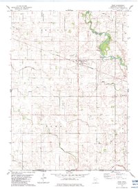
1982 Map of Frost
USGS Topo · Published 1983About this map
Agricultural patterns in southern Minnesota are defined by a complex grid of water management and rail transport in this early 1980s survey. The town of Frost serves as the central hub, situated along the Chicago and North Western railroad line and featuring a prominent Radio Tower. The landscape is characterized by the meandering East Branch Blue Earth River and Brush Creek, which are supplemented by an extensive system of man-made waterways including Judicial Ditch No 13 and County Ditch No 8. These ditches illustrate the intensive engineering required to maintain the productivity of the surrounding Emerald and Rome townships. Local heritage sites like Emerald Cem and Bethany Ch provide fixed points of historical reference amidst the shifting agricultural plots and scattered Gravel Pit operations near the river banks.
Find a feature on this map
24 named features on this map. Tap any name to fly to it.
Don’t see what you’re looking for? This feature index may not catch every label — zoom into the map to look around manually.
Map Details
Editions of this 1982 Frost Map
This is the sole edition of this map. No revisions or reprints were ever made.
Other maps of this area

1954 · Fairmont
USGS Topo · 1:250,000

1954 · Mason City
USGS Topo · 1:250,000

1955 · Bricelyn
USGS Topo · 1:62,500

1957 · Mason City
USGS Topo · 1:250,000

1958 · Mason City
USGS Topo · 1:250,000

1958 · Fairmont
USGS Topo · 1:250,000

1967 · Elmore
USGS Topo · 1:24,000
1967 · Blue Earth
USGS Topo · 1:24,000

1972 · Buffalo Center
USGS Topo · 1:24,000

1972 · Buffalo Center NE
USGS Topo · 1:24,000