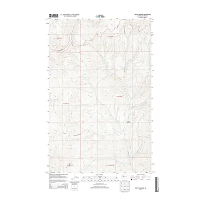
2014 Map of Frosty Meadow
USGS Topo · Published 2014About this map
Frosty Meadow sits at the heart of this high-elevation landscape within the northern reaches of the Colville Indian Reservation. The terrain is defined by a dense network of mountain drainages, including Ninemile Cr, Pollock Cr, and Klondyke Cr, which carve through the territory. This 2014 survey documents the modern road infrastructure used to navigate the Ferry County backcountry, notably Frosty Meadows Rd and several Bureau of Indian Affairs routes like Bia 1125 RD and Bia 1128 RD. The map illustrates a transitional landscape where high-mountain meadows meet managed forest lands, providing a clear record of the watershed patterns and land management boundaries within the reservation at the start of the 21st century.
Find a feature on this map
26 named features on this map. Tap any name to fly to it.
Don’t see what you’re looking for? This feature index may not catch every label — zoom into the map to look around manually.
Map Details
Editions of this 2014 Frosty Meadow Map
This is the sole edition of this map. No revisions or reprints were ever made.
Other maps of this area

1948 · Wilmont Creek
USGS Topo · 1:62,500

1950 · Wilmont Creek
USGS Topo · 1:62,500

1952 · Keller
USGS Topo · 1:62,500

1952 · Twin Lakes
USGS Topo · 1:62,500

1953 · Seventeenmile Mtn.
USGS Topo · 1:62,500

1954 · Okanogan
USGS Topo · 1:250,000

1956 · Wilmont Creek
USGS Topo · 1:62,500

1958 · Okanogan
USGS Topo · 1:250,000

1984 · Nespelem
USGS Topo · 1:100,000
1985 · Ninemile Flat
USGS Topo · 1:24,000