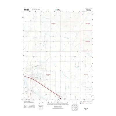
2013 Map of Fruita
USGS Topo · Published 2013About this map
Fruita serves as the focal point of this 2013 topographic study, revealing a landscape defined by an intricate network of irrigation systems critical to the Grand Valley. The movement of water is meticulously tracked through the Main Line Grand Valley Canal, the Government Highline Canal, and the Independent Ranchmens Ditch, showing how the arid terrain north of the Colorado River was reclaimed for agriculture. This engineering legacy is overlaid by a rigid grid of rural roads, including 18 Rd and K Rd, which connect outlying areas like Rhone back to the city center.
Find a feature on this map
75 named features on this map. Tap any name to fly to it.
Don’t see what you’re looking for? This feature index may not catch every label — zoom into the map to look around manually.
Map Details
Editions of this 2013 Fruita Map
This is the sole edition of this map. No revisions or reprints were ever made.
Other maps of this area

1934 · Colorado National Monument
USGS Topo · 1:24,000

1956 · Grand Junction
USGS Topo · 1:250,000

1959 · Grand Junction
USGS Topo · 1:250,000

1960 · Grand Junction
USGS Topo · 1:250,000

1962 · Grand Junction
USGS Topo · 1:250,000

1962 · Fruita
USGS Topo · 1:24,000

1962 · Mack
USGS Topo · 1:24,000

1962 · Colorado National Monument
USGS Topo · 1:24,000
1962 · Battleship Rock
USGS Topo · 1:24,000

1962 · Grand Junction
USGS Topo · 1:24,000