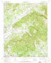
1965 Map of Fruitland
USGS Topo · Published 1973About this map
Hendersonville and the Fletcher community anchor this mid-1960s study of the plateau between the Blue Ridge and the Buncombe County line. The landscape is defined by the transition from the broad valleys of Cane Creek and Mud Creek into the steep rises of Bearwallow Mtn and Burney Mountain. Significant institutional development is evident at the Mountain Sanitarium and Fletcher Academy and the historic Christ School campus. On the western edge, the Southern Railway corridor runs parallel to the Dixie Hwy, while an abandoned Asheville-Hendersonville Airport provides a record of early regional aviation. Smaller settlements like Fruitland are shown with local landmarks such as the Fruitland Bible Institute and numerous rural houses of worship including Tweed Chapel and Oak Forest Ch, reflecting the area's deep-rooted community structure before later-century expansion.
Find a feature on this map
125 named features on this map. Tap any name to fly to it.
Don’t see what you’re looking for? This feature index may not catch every label — zoom into the map to look around manually.
Map Details
Editions of this 1965 Fruitland Map
4 editions found
Other maps of this area

1894 · Asheville
USGS Topo · 1:125,000

1900 · Mount Mitchell
USGS Topo · 1:125,000

1901 · Asheville
USGS Topo · 1:125,000

1902 · Mount Mitchell
USGS Topo · 1:125,000

1905 · Pisgah
USGS Topo · 1:125,000

1906 · Pisgah
USGS Topo · 1:125,000

1907 · Saluda
USGS Topo · 1:125,000

1935 · Horse Shoe
USGS Topo · 1:24,000

1935 · Batcave
USGS Topo · 1:24,000

1935 · Hendersonville
USGS Topo · 1:24,000