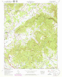
1965 Map of Fruitland
USGS Topo · Published 1979About this map
Fruitland and the surrounding Blue Ridge foothills are defined by a high-elevation landscape where small agricultural clearings and institutional campuses are tucked between prominent peaks. Significant educational and religious landmarks anchor the community, including the Fruitland Bible Institute and the sprawling grounds of Christ School near Mountain View. The map captures the area's transition into a center for health and education, noted by the presence of the Mountain Sanitarium and Fletcher Academy. Transport patterns follow the natural terrain, with the Southern Railway skirting the western edge through Fletcher, while smaller routes like Howard Gap Road wind through the gaps.
Find a feature on this map
98 named features on this map. Tap any name to fly to it.
Don’t see what you’re looking for? This feature index may not catch every label — zoom into the map to look around manually.
Map Details
Editions of this 1965 Fruitland Map
4 editions found
Other maps of this area

1894 · Asheville
USGS Topo · 1:125,000

1900 · Mount Mitchell
USGS Topo · 1:125,000

1901 · Asheville
USGS Topo · 1:125,000

1902 · Mount Mitchell
USGS Topo · 1:125,000

1905 · Pisgah
USGS Topo · 1:125,000

1906 · Pisgah
USGS Topo · 1:125,000

1907 · Saluda
USGS Topo · 1:125,000

1935 · Horse Shoe
USGS Topo · 1:24,000

1935 · Batcave
USGS Topo · 1:24,000

1935 · Hendersonville
USGS Topo · 1:24,000