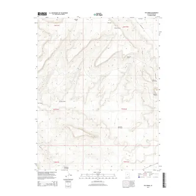
2014 Map of Fry Spring
USGS Topo · Published 2014About this map
Wingate Mesa and the prominent Moss Back ridge dominate this high-desert landscape in San Juan County, where the terrain is deeply incised by a complex network of drainage systems. The map detail highlights the hydrological importance of Fry Spring near the head of Fry Canyon in an otherwise arid environment. This 2014 survey documents the modern road network essential for navigating the remote plateau, including Radium King Rd and Red Canyon Rd, which follow the contours of the mesa tops and canyon floors. The landscape is punctuated by distinctive geological features such as the Tables of the Sun and the Tables of the Sun Hills to the east. These landforms, alongside the branching reaches of North Fork Red Canyon and South Fork Red Canyon, define a region shaped by erosional forces and utilized for its mineral and natural resources.
Find a feature on this map
22 named features on this map. Tap any name to fly to it.
Don’t see what you’re looking for? This feature index may not catch every label — zoom into the map to look around manually.
Map Details
Editions of this 2014 Fry Spring Map
This is the sole edition of this map. No revisions or reprints were ever made.
Other maps of this area

1886 · Henry Mountains
USGS Topo · 1:250,000

1892 · Henry Mountains
USGS Topo · 1:250,000

1952 · Mancos Mesa
USGS Topo · 1:62,500

1952 · Natural Bridges
USGS Topo · 1:62,500

1954 · White Canyon 3 SE
USGS Topo · 1:24,000

1954 · White Canyon 4 NE
USGS Topo · 1:24,000

1954 · White Canyon 4 SE
USGS Topo · 1:24,000

1954 · White Canyon 3 NE
USGS Topo · 1:24,000

1954 · White Canyon 4 SW
USGS Topo · 1:24,000
1954 · White Canyon 4 NW
USGS Topo · 1:24,000