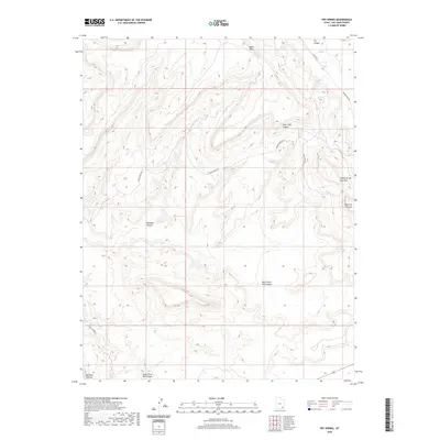
2020 Map of Fry Spring
USGS Topo · Published 2020About this map
Red Rock Plateau defines the landscape of this high-desert region in San Juan County, where deep drainages and flat-topped mesas reflect the complex geology of southeastern Utah. The topography is dominated by dramatic canyon systems, including the North Fork Red Canyon and South Fork Red Canyon, which converge toward the western edge of the sheet. Higher elevations are marked by distinctive landmarks such as Moss Back and the isolated heights of the Tables of the Sun. Access through this remote terrain is primarily limited to rugged corridors like Radium King Rd and Moss Back Rd, which trace the contours of the plateaus. Notable water sources are rare in this arid environment, making features like Fry Spring in the northeast and tucked-away basins like Bullseye Canyon significant markers for those navigating the backcountry.
Find a feature on this map
13 named features on this map. Tap any name to fly to it.
Don’t see what you’re looking for? This feature index may not catch every label — zoom into the map to look around manually.
Map Details
Editions of this 2020 Fry Spring Map
This is the sole edition of this map. No revisions or reprints were ever made.
Other maps of this area

1886 · Henry Mountains
USGS Topo · 1:250,000

1892 · Henry Mountains
USGS Topo · 1:250,000

1952 · Mancos Mesa
USGS Topo · 1:62,500

1952 · Natural Bridges
USGS Topo · 1:62,500

1954 · White Canyon 3 SE
USGS Topo · 1:24,000

1954 · White Canyon 4 NE
USGS Topo · 1:24,000

1954 · White Canyon 4 SE
USGS Topo · 1:24,000

1954 · White Canyon 3 NE
USGS Topo · 1:24,000

1954 · White Canyon 4 SW
USGS Topo · 1:24,000
1954 · White Canyon 4 NW
USGS Topo · 1:24,000