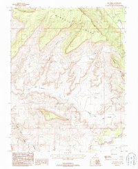
1987 Map of Fry Spring
USGS Topo · Published 1987About this map
Wingate Mesa and the surrounding high desert of San Juan County dominate this late-twentieth-century landscape, revealing a topography defined by erosion and mineral exploration. This 1987 survey documents a network of mining activity, indicated by numerous Prospect and Adit labels scattered across the drainage basins of North Fork Red Canyon and South Fork Red Canyon. These marks suggest a period of active geological investigation or small-scale mining ventures common to this part of the Colorado Plateau.
Find a feature on this map
10 named features on this map. Tap any name to fly to it.
Don’t see what you’re looking for? This feature index may not catch every label — zoom into the map to look around manually.
Map Details
Editions of this 1987 Fry Spring Map
This is the sole edition of this map. No revisions or reprints were ever made.
Other maps of this area

1886 · Henry Mountains
USGS Topo · 1:250,000

1892 · Henry Mountains
USGS Topo · 1:250,000

1952 · Mancos Mesa
USGS Topo · 1:62,500

1952 · Natural Bridges
USGS Topo · 1:62,500

1954 · White Canyon 3 SE
USGS Topo · 1:24,000

1954 · White Canyon 4 NE
USGS Topo · 1:24,000

1954 · White Canyon 4 SE
USGS Topo · 1:24,000

1954 · White Canyon 3 NE
USGS Topo · 1:24,000

1954 · White Canyon 4 SW
USGS Topo · 1:24,000
1954 · White Canyon 4 NW
USGS Topo · 1:24,000