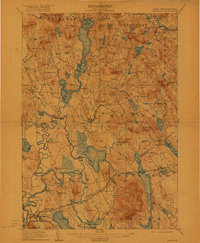
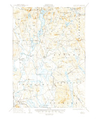
1911 Map of Fryeburg
USGS Topo · Published 1922About this map
Fryeburg and the surrounding borderlands of Oxford County emerge at a time when the Saco River was the primary corridor of the region, its meanders creating a complex landscape of oxbows and islands. The village of Fryeburg Center and nearby Fish Street anchor the southern valley, while the northern terrain is dominated by the expansive waters of Upper Kezar Lake and Lower Bay. This early 20th-century landscape is dotted with neighborhood educational landmarks like Menotomy School and Union Hill School, reflecting a decentralized settlement pattern of small farming and timber hamlets.
Find a feature on this map
175 named features on this map. Tap any name to fly to it.
Don’t see what you’re looking for? This feature index may not catch every label — zoom into the map to look around manually.
Map Details
Editions of this 1911 Fryeburg Map
6 editions found
Other maps of this area

1893 · Gorham
USGS Topo · 1:62,500

1894 · North Conway
USGS Topo · 1:62,500

1896 · Norway
USGS Topo · 1:62,500

1896 · Sebago
USGS Topo · 1:62,500

1896 · North Conway
USGS Topo · 1:62,500

1896 · Gorham
USGS Topo · 1:62,500

1909 · Fryeburg
USGS Topo · 1:62,500

1910 · Kezar Falls
USGS Topo · 1:48,000

1911 · Fryeburg
USGS Topo · 1:62,500

1911 · Kezar Falls
USGS Topo · 1:62,500