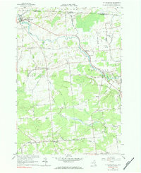
1964 Map of Ft. Covington
USGS Topo · Published 1984About this map
The Salmon River snakes through this borderland landscape in northern Franklin County, defining the settlement patterns of Ft Covington and Westville. This mid-century survey captures the rural character of the region just south of the United States - Canada border, where the Grand Trunk railroad line passes through the northern reaches of the village. The terrain is marked by numerous gravel operations and small creeks like Deer Creek and Plum Brook, which drain toward the international boundary.
Find a feature on this map
60 named features on this map. Tap any name to fly to it.
Don’t see what you’re looking for? This feature index may not catch every label — zoom into the map to look around manually.
Map Details
Editions of this 1964 Ft. Covington Map
2 editions found
Other maps of this area

1915 · Malone
USGS Topo · 1:62,500

1915 · Moira
USGS Topo · 1:62,500

1917 · Malone
USGS Topo · 1:62,500

1917 · Moira
USGS Topo · 1:62,500

1944 · Moira
USGS Topo · 1:62,500

1948 · Ogdensburg
USGS Topo · 1:250,000

1951 · Ogdensburg
USGS Topo · 1:250,000

1953 · Ogdensburg
USGS Topo · 1:250,000

1961 · Ogdensburg
USGS Topo · 1:250,000
1964 · Ft. Covington
USGS Topo · 1:24,000