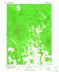
1960 Map of Fuego Mountain
USGS Topo · Published 1965About this map
Fuego Mountain stands as a central landmark in this high-elevation region of south-central Oregon during the late 1950s and early 1960s. The landscape is defined by the convergence of the Winema National Forest and Fremont National Forest, showing a network of resource management through features like the Fuego Fire Road and several remote airstrips. Significant water systems, including the Williamson River and Sycan River, carve through the timbered terrain, while the presence of the Yamsay Ranch and the Indian Reservation Bdy along the northern edge indicates a blend of private agriculture and tribal lands. Local history and geography are preserved through family-named sites and landmarks such as Teddy Powers Meadow, Buckmaster Point, and the Tim Brown Spring, which provide specific points of reference for those studying the area's grazing and timber history before modern development.
Find a feature on this map
50 named features on this map. Tap any name to fly to it.
Don’t see what you’re looking for? This feature index may not catch every label — zoom into the map to look around manually.
Map Details
Editions of this 1960 Fuego Mountain Map
2 editions found

Other maps of this area

1889 · Klamath
USGS Topo · 1:250,000

1894 · Klamath
USGS Topo · 1:250,000

1955 · Klamath Falls
USGS Topo · 1:250,000

1956 · Calimus Butte
USGS Topo · 1:62,500

1957 · Klamath Marsh
USGS Topo · 1:62,500

1957 · Swan Lake
USGS Topo · 1:62,500

1958 · Klamath Falls
USGS Topo · 1:250,000

1960 · Riverbed Butte
USGS Topo · 1:62,500

1960 · Sycan Marsh
USGS Topo · 1:62,500

1960 · Bly
USGS Topo · 1:62,500