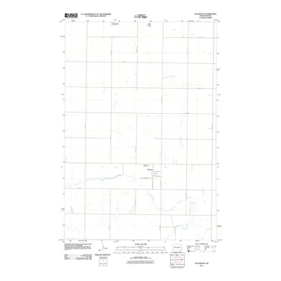
2011 Map of Fullerton
USGS Topo · Published 2011About this map
Fullerton serves as the central hub of this prairie landscape, where the town’s grid is defined by streets like Minneapolis Ave and Southworth Ave. Just north of the main residential area lies Maple View Cemetery, a significant point of interest for genealogists and local historians. The surrounding terrain is characterized by the meandering path of the Maple River, which winds through the southern portion of the quadrangle. Beyond the town limits, the agricultural character of the region is evident through private aviation markers such as the Leiseth Farms Landing Strip and Larson Landing Strip. This map provides a clear view of the section-line road network, including routes like 92nd Ave SE and 81st St SE, which have dictated the layout of North Dakota’s farmland for generations.
Find a feature on this map
20 named features on this map. Tap any name to fly to it.
Don’t see what you’re looking for? This feature index may not catch every label — zoom into the map to look around manually.
Map Details
Editions of this 2011 Fullerton Map
This is the sole edition of this map. No revisions or reprints were ever made.
Other maps of this area

1894 · Monango
USGS Topo · 1:62,500

1894 · La Moure
USGS Topo · 1:62,500

1894 · Fullerton
USGS Topo · 1:62,500

1895 · Lamoure
USGS Topo · 1:125,000

1896 · Edgeley
USGS Topo · 1:125,000

1918 · La Moure
USGS Topo · 1:125,000

1925 · Edgeley
USGS Topo · 1:125,000

1953 · Jamestown
USGS Topo · 1:250,000

1955 · Fullerton NE
USGS Topo · 1:24,000
1955 · Fullerton SE
USGS Topo · 1:24,000