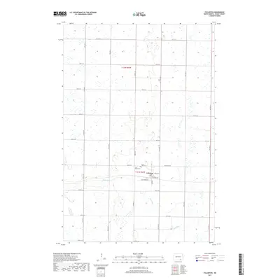
2017 Map of Fullerton
USGS Topo · Published 2017About this map
Fullerton serves as the central hub of this Dickey County landscape, where the grid of the North Dakota prairie meets the meandering course of the Maple River. The town's layout is defined by named thoroughfares such as Minneapolis Ave, Southworth Ave, and Monroe St, suggesting a community established with structured growth in mind. On the outskirts of the settlement, Maple View Cem and Saint Patricks Cem provide significant points of interest for genealogists and local historians, anchoring the lineages of the region's families to this specific patch of the Plains. Beyond the town limits, the geography is characterized by a dense network of section-line roads and numerous small wetlands, illustrating the typical agricultural drainage patterns of the era.
Find a feature on this map
28 named features on this map. Tap any name to fly to it.
Don’t see what you’re looking for? This feature index may not catch every label — zoom into the map to look around manually.
Map Details
Editions of this 2017 Fullerton Map
This is the sole edition of this map. No revisions or reprints were ever made.
Other maps of this area

1894 · Monango
USGS Topo · 1:62,500

1894 · La Moure
USGS Topo · 1:62,500

1894 · Fullerton
USGS Topo · 1:62,500

1895 · Lamoure
USGS Topo · 1:125,000

1896 · Edgeley
USGS Topo · 1:125,000

1918 · La Moure
USGS Topo · 1:125,000

1925 · Edgeley
USGS Topo · 1:125,000

1953 · Jamestown
USGS Topo · 1:250,000

1955 · Fullerton NE
USGS Topo · 1:24,000
1955 · Fullerton SE
USGS Topo · 1:24,000