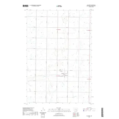
2020 Map of Fullerton
USGS Topo · Published 2020About this map
Fullerton serves as the primary hub of this Dickey County landscape, where the town grid meets the meandering path of the Maple River. This 2020 survey illustrates the organized section lines of the Public Land Survey System, with townships t132n r62w and t131n r62w defining the local geography. Local history is anchored by the presence of Saint Patricks Cem and Maple View Cem, situated just north of the central settlement. The transportation network is a strict cardinal grid of rural roads, such as 91st Ave SE and 86th St SE, which facilitate access to the surrounding agricultural tracts. Within the town limits, the intersection of Minneapolis Ave and Southworth Ave provides a look at the community's structural layout in the early 21st century.
Find a feature on this map
30 named features on this map. Tap any name to fly to it.
Don’t see what you’re looking for? This feature index may not catch every label — zoom into the map to look around manually.
Map Details
Editions of this 2020 Fullerton Map
This is the sole edition of this map. No revisions or reprints were ever made.
Other maps of this area

1894 · Monango
USGS Topo · 1:62,500

1894 · La Moure
USGS Topo · 1:62,500

1894 · Fullerton
USGS Topo · 1:62,500

1895 · Lamoure
USGS Topo · 1:125,000

1896 · Edgeley
USGS Topo · 1:125,000

1918 · La Moure
USGS Topo · 1:125,000

1925 · Edgeley
USGS Topo · 1:125,000

1953 · Jamestown
USGS Topo · 1:250,000

1955 · Fullerton NE
USGS Topo · 1:24,000
1955 · Fullerton SE
USGS Topo · 1:24,000