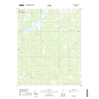
2020 Map of Fulton NE
USGS Topo · Published 2020About this map
Moores Mill and Sandy Springs anchor this corner of Northeast Mississippi, where the boundaries of Prentiss, Tishomingo, and Itawamba counties converge. The landscape is defined by the meandering course of Mackeys Creek and its many tributaries, including Red Bud Cr and Saucer Cr. A deep network of local roads like Ryan Salem Rd and Walker Level Rd connects numerous family and community landmarks. Genealogists will find significant value in the high density of burial sites across these townships, ranging from the Old Bethel Cem in the east to the Burnt Field Cem in the southwest. The presence of Caveness Bridge and the Natchez Trace Parkway in the northwest quadrant highlights the historical importance of this area as a transit corridor, bridging the small rural settlements and agricultural lands that have persisted through the decades.
Find a feature on this map
74 named features on this map. Tap any name to fly to it.
Don’t see what you’re looking for? This feature index may not catch every label — zoom into the map to look around manually.
Map Details
Editions of this 2020 Fulton NE Map
This is the sole edition of this map. No revisions or reprints were ever made.
Other maps of this area

1936 · Belmont
USGS Topo · 1:24,000

1936 · Red Bay
USGS Topo · 1:24,000

1950 · Belmont
USGS Topo · 1:24,000

1951 · Red Bay
USGS Topo · 1:24,000
1951 · Belmont
USGS Topo · 1:24,000

1956 · Tupelo
USGS Topo · 1:250,000

1958 · Tupelo
USGS Topo · 1:250,000
1965 · Paden SE
USGS Topo · 1:24,000

1965 · Fulton SE
USGS Topo · 1:24,000

1965 · Fulton
USGS Topo · 1:24,000