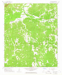
1965 Map of Fulton NE
USGS Topo · Published 1966About this map
The hills of northeast Mississippi, where Itawamba, Tishomingo, and Prentiss counties meet, are characterized by a network of family-named cemeteries and rural congregations. During this mid-century period, the Natchez Trace Pkwy Under Construction cuts through the northwest corner of the quadrangle, marking a modern transition for this landscape. The terrain is deeply carved by watercourses like Mackeys Creek and Red Bud Creek, which supported early local industry at sites such as Moores Mill.
Find a feature on this map
38 named features on this map. Tap any name to fly to it.
Don’t see what you’re looking for? This feature index may not catch every label — zoom into the map to look around manually.
Map Details
Editions of this 1965 Fulton NE Map
This is the sole edition of this map. No revisions or reprints were ever made.
Other maps of this area

1936 · Belmont
USGS Topo · 1:24,000

1936 · Red Bay
USGS Topo · 1:24,000

1950 · Belmont
USGS Topo · 1:24,000

1951 · Red Bay
USGS Topo · 1:24,000
1951 · Belmont
USGS Topo · 1:24,000

1956 · Tupelo
USGS Topo · 1:250,000

1958 · Tupelo
USGS Topo · 1:250,000
1965 · Paden SE
USGS Topo · 1:24,000

1965 · Fulton SE
USGS Topo · 1:24,000

1965 · Fulton
USGS Topo · 1:24,000