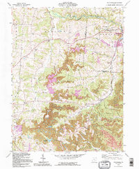
1992 Map of Fultonham
USGS Topo · Published 1995About this map
The rolling landscape of Perry and Muskingum Counties is defined by its deep coal-mining history and the extensive Perry State Forest. The map shows a region shaped by industrial activity, where the presence of a Strip Mine and Step Mine suggests the heavy extraction that occurred around Redfield and East Fultonham. Genealogists will find a wealth of local landmarks including numerous family and community burial grounds such as Uniontown Cem, Bethel Cem, and the Madison Sch cemetery. Waterways like Jonathan Creek and Butcherknife Creek cut through the terrain, while the social life of the era is anchored by local institutions like Grange Hall and Wesley Chapel. The topographic detail preserves the locations of rural schoolhouses and small settlements such as Sego and Saltillo during a period of industrial transition.
Find a feature on this map
44 named features on this map. Tap any name to fly to it.
Don’t see what you’re looking for? This feature index may not catch every label — zoom into the map to look around manually.
Map Details
Editions of this 1992 Fultonham Map
This is the sole edition of this map. No revisions or reprints were ever made.
Other maps of this area

1907 · Logan
USGS Topo · 1:62,500

1909 · Thornville
USGS Topo · 1:62,500

1909 · Logan
USGS Topo · 1:62,500

1910 · Zanesville
USGS Topo · 1:62,500

1911 · New Lexington
USGS Topo · 1:62,500

1947 · Columbus
USGS Topo · 1:250,000

1961 · Columbus
USGS Topo · 1:250,000

1961 · New Lexington
USGS Topo · 1:24,000

1961 · Deavertown
USGS Topo · 1:24,000

1961 · Zanesville West
USGS Topo · 1:24,000