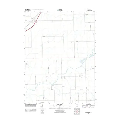
2012 Map of Funks Grove
USGS Topo · Published 2012About this map
Funks Grove serves as the focal point for this section of McLean County, where the agricultural landscape is defined by the winding course of Kickapoo Cr and its tributaries. The map documents a rural environment shaped by the intersection of traditional travel routes and modern aviation, notably featuring Old Route 66 cutting across the northwestern corner. The distribution of family and community landmarks provides significant detail for local historians, with sites like Fremont Cem, Fairview Cem, and Halsey Cem preserved among the grid of county roads. Small-scale aviation is a distinct characteristic of the area, evidenced by the presence of Holland Field Airport, WM Quinton RLA Airport, and the Holt Landing Strip. This drainage basin, which includes Short Point Cr and Long Point Cr, reflects the persistent drainage patterns that have dictated field boundaries and farm placement for generations.
Find a feature on this map
65 named features on this map. Tap any name to fly to it.
Don’t see what you’re looking for? This feature index may not catch every label — zoom into the map to look around manually.
Map Details
Editions of this 2012 Funks Grove Map
This is the sole edition of this map. No revisions or reprints were ever made.
Other maps of this area

1949 · Mc Lean
USGS Topo · 1:62,500

1951 · McLean
USGS Topo · 1:62,500

1951 · Le Roy
USGS Topo · 1:62,500

1957 · Kenney
USGS Topo · 1:62,500

1957 · Maroa
USGS Topo · 1:62,500

1958 · Peoria
USGS Topo · 1:250,000

1961 · Peoria
USGS Topo · 1:250,000

1963 · Peoria
USGS Topo · 1:250,000
1979 · Clinton
USGS Topo · 1:24,000
1980 · Waynesville East
USGS Topo · 1:24,000