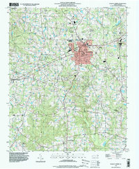
1993 Map of Fuquay-Varina
USGS Topo · Published 1999About this map
Fuquay-Varina serves as the central hub of this 1990s survey, where the town's grid expands across the Wake Co and Harnett Co border. The landscape is defined by its transition from a structured municipal center, featuring the Municipal Bldg and Hospital, to the surrounding rural pockets and smaller communities. Historically significant nodes like Chalybeate Springs and the crossroads at Rawls highlight the enduring settlement patterns of southern Wake County.
Find a feature on this map
39 named features on this map. Tap any name to fly to it.
Don’t see what you’re looking for? This feature index may not catch every label — zoom into the map to look around manually.
Map Details
Editions of this 1993 Fuquay-Varina Map
This is the sole edition of this map. No revisions or reprints were ever made.
Other maps of this area

1953 · Raleigh
USGS Topo · 1:250,000

1954 · Raleigh
USGS Topo · 1:250,000

1964 · Lake Wheeler
USGS Topo · 1:24,000

1964 · Angier
USGS Topo · 1:24,000

1964 · Garner
USGS Topo · 1:62,500

1973 · Coats
USGS Topo · 1:24,000

1974 · Apex
USGS Topo · 1:24,000
1974 · Fuquay-Varina
USGS Topo · 1:24,000
1974 · New Hill
USGS Topo · 1:24,000

1974 · Mamers
USGS Topo · 1:24,000