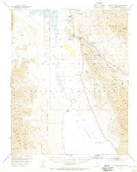
1952 Map of Furnace Creek
USGS Topo · Published 1955About this map
Furnace Creek Ranch and the Furnace Creek Inn serve as central hubs in this mid-century survey of the heart of Death Valley National Monument. The landscape is a stark study in extreme elevations, ranging from the high peaks of the Panamint Range to the depths of the Death Valley (Depression). Local history is recorded in the Harmony Borax Works (Ruins) and the Indian Village situated near the valley floor. Transportation and geological oddities define the terrain, from the Airport and Artists Drive to the crystalline expanses of the Devils Golf Course. Notable landmarks such as Zabriskie Pt, Mushroom Rock, and the Natural Bridge are precisely documented alongside water sources like Travertine Springs and Salt Springs. Small industrial markers include scattered Mines and a Cem located near the ranch.
Find a feature on this map
75 named features on this map. Tap any name to fly to it.
Don’t see what you’re looking for? This feature index may not catch every label — zoom into the map to look around manually.
Map Details
Editions of this 1952 Furnace Creek Map
5 editions found
Other maps of this area

1908 · Furnace Creek
USGS Topo · 1:250,000

1908 · Ballarat
USGS Topo · 1:250,000

1910 · Furnace Creek
USGS Topo · 1:250,000

1913 · Ballarat
USGS Topo · 1:250,000

1942 · Bullfrog
USGS Topo · 1:125,000

1948 · Death Valley
USGS Topo · 1:250,000

1951 · Funeral Peak
USGS Topo · 1:62,500

1952 · Chloride Cliff
USGS Topo · 1:50,000

1952 · Stovepipe Wells
USGS Topo · 1:62,500

1952 · Furnace Creek
USGS Topo · 1:62,500