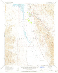
1952 Map of Furnace Creek
USGS Topo · Published 1961About this map
Harmony Borax Works (Ruins) stands as a marker of the industrial extraction that once defined this portion of the Death Valley National Monument. In the early 1950s, the valley floor was a complex of specialized environments, from the concentrated habitation at Furnace Creek Ranch and the nearby Indian Village to the desolate crystallization of the Devils Golf Course. Transportation and tourism infrastructure are evident through the Airport and the winding path of Artists Drive, which leads toward the vivid geology of the Artists Palette.
Find a feature on this map
38 named features on this map. Tap any name to fly to it.
Don’t see what you’re looking for? This feature index may not catch every label — zoom into the map to look around manually.
Map Details
Editions of this 1952 Furnace Creek Map
5 editions found
Other maps of this area

1908 · Furnace Creek
USGS Topo · 1:250,000

1908 · Ballarat
USGS Topo · 1:250,000

1910 · Furnace Creek
USGS Topo · 1:250,000

1913 · Ballarat
USGS Topo · 1:250,000

1942 · Bullfrog
USGS Topo · 1:125,000

1948 · Death Valley
USGS Topo · 1:250,000

1951 · Funeral Peak
USGS Topo · 1:62,500

1952 · Chloride Cliff
USGS Topo · 1:50,000

1952 · Stovepipe Wells
USGS Topo · 1:62,500

1952 · Furnace Creek
USGS Topo · 1:62,500