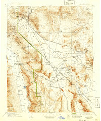
1910 Map of Furnace Creek
USGS Topo · Published 1941About this map
The mining boomtown of Rhyolite and the adjacent Bullfrog district define the northern reaches of this survey, capturing the industrial pulse of the Nevada desert before many of these camps faded. The map traces the vital rail connections of the era, including the Tonopah and Las Vegas RR and the Tidewater and Tonopah RR, which serviced the remote mineral claims. To the west, the dramatic drop into Death Valley reveals a landscape of extremes, where isolated outposts like Furnace Creek Ranch and Bennetts Well provided rare water sources in a region dominated by Salt Flats and mineral works. The survey documents significant early 20th-century industry, from the Keane Wonder Mine near Chloride Cliff to the Borax Mill and Lila C Mine, illustrating the intense effort to extract wealth from the Amargosa Desert and surrounding ranges.
Find a feature on this map
136 named features on this map. Tap any name to fly to it.
Don’t see what you’re looking for? This feature index may not catch every label — zoom into the map to look around manually.
Map Details
Editions of this 1910 Furnace Creek Map
5 editions found
Other maps of this area

1907 · Las Vegas
USGS Topo · 1:250,000

1908 · Kawich
USGS Topo · 1:250,000

1908 · Lida
USGS Topo · 1:250,000

1908 · Furnace Creek
USGS Topo · 1:250,000

1908 · Las Vegas
USGS Topo · 1:250,000

1908 · Ballarat
USGS Topo · 1:250,000

1910 · Furnace Creek
USGS Topo · 1:250,000

1910 · Ivanpah
USGS Topo · 1:250,000

1912 · Ivanpah
USGS Topo · 1:250,000

1913 · Lida
USGS Topo · 1:250,000