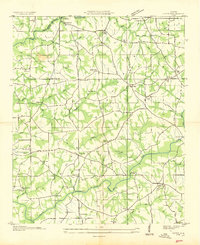
1936 Map of Fyffe
USGS Topo · Published 1936About this map
Sand Mountain dominates the landscape of this 1936 Tennessee Valley Authority and USGS survey, where rural life in the Depression era is marked by a dense network of country schools and churches. The upland terrain is carved by the deep drainage of South Sauty Creek and the notable Bucks Pocket area to the northwest. Settlement is concentrated around small hubs like Fyffe and Gibson Crossroads, with the geography defined by local landmarks such as Old Sauty Mill Bridge and the Lebanon Ford Bridge spanning Town Creek.
Find a feature on this map
67 named features on this map. Tap any name to fly to it.
Don’t see what you’re looking for? This feature index may not catch every label — zoom into the map to look around manually.
Map Details
Editions of this 1936 Fyffe Map
This is the sole edition of this map. No revisions or reprints were ever made.
Other maps of this area

1885 · Gadsden
USGS Topo · 1:125,000

1886 · Stevenson
USGS Topo · 1:125,000

1888 · Gadsden
USGS Topo · 1:125,000

1888 · Scottsboro
USGS Topo · 1:125,000

1892 · Scottsboro
USGS Topo · 1:125,000

1892 · Stevenson
USGS Topo · 1:125,000

1892 · Gadsden
USGS Topo · 1:125,000

1893 · Fort Payne
USGS Topo · 1:125,000

1895 · Stevenson
USGS Topo · 1:125,000

1895 · Gadsden
USGS Topo · 1:125,000