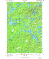
1957 Map of Gabbro Lake
USGS Topo · Published 1972About this map
Superior National Forest dominates this mid-century survey of northeastern Minnesota’s lake country. The landscape is an intricate network of water and portages, centered around Moose Lake, Newton Lake, and the sprawling Mile Island Lake. Evidence of early hydraulic management and forest service infrastructure appears through features like Dam No 1, Dam No 2, and a Gaging Station, reflecting the era's focus on water resource management within the wilderness.
Find a feature on this map
92 named features on this map. Tap any name to fly to it.
Don’t see what you’re looking for? This feature index may not catch every label — zoom into the map to look around manually.
Map Details
Editions of this 1957 Gabbro Lake Map
3 editions found
Other maps of this area

1933 · Ely
USGS Topo · 1:62,500

1939 · Ely
USGS Topo · 1:62,500

1952 · Babbitt NE
USGS Topo · 1:24,000

1954 · Greenwood Lake
USGS Topo · 1:62,500

1954 · Two Harbors
USGS Topo · 1:250,000

1955 · Isabella
USGS Topo · 1:62,500

1957 · Two Harbors
USGS Topo · 1:250,000

1957 · Gabbro Lake
USGS Topo · 1:62,500

1957 · Ensign Lake
USGS Topo · 1:62,500

1957 · Basswood Lake
USGS Topo · 1:62,500