
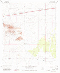
1963 Map of Gage
USGS Topo · Published 1966About this map
The Victorio Mountains dominate this high-desert landscape in Luna County, rising sharply above the level plains where the Southern Pacific railroad runs parallel to U.S. Routes 70 and 80. The small settlement of Gage serves as a focal point along these transit corridors, reflecting the area's role as a transportation artery in southwestern New Mexico.
Find a feature on this map
22 named features on this map. Tap any name to fly to it.
Don’t see what you’re looking for? This feature index may not catch every label — zoom into the map to look around manually.
Map Details
Editions of this 1963 Gage Map
2 editions found
Other maps of this area

1899 · Deming
USGS Topo · 1:125,000

1915 · Deming
USGS Topo · 1:125,000

1954 · Silver City
USGS Topo · 1:250,000

1955 · Las Cruces
USGS Topo · 1:250,000

1958 · Las Cruces
USGS Topo · 1:250,000

1958 · Silver City
USGS Topo · 1:250,000

1962 · Silver City
USGS Topo · 1:250,000

1963 · Gage SW
USGS Topo · 1:24,000

1963 · Gage NW
USGS Topo · 1:24,000
1963 · Grandmother Mountain West
USGS Topo · 1:24,000