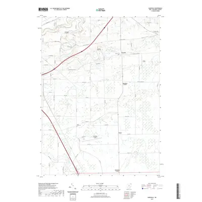
2019 Map of Gageville
USGS Topo · Published 2019About this map
The Ashtabula River carves a winding path through this corner of Ashtabula County, shaping the settlement patterns of small communities like Gageville and Sheffield Center. The landscape is a network of rural townships defined by historic river crossings, such as the Olin-Dewey Road Bridge and Benetka Road Bridge, which provide critical links across the water. To the south, the Northeast Ohio Regional Airport introduces a modern transit footprint amidst the established agricultural and residential layout of Bulah and Denmark Center. Local history and genealogy are anchored by sites such as Gageville Cem and Griggs Corners Cem, while the presence of Victor's Landing suggests long-standing riverfront activity. Numerous small waterways, including Coffee Cr and Griggs Creek, traverse the terrain, reflecting the drainage patterns that have historically dictated road placement and land use in this part of Northeast Ohio.
Find a feature on this map
69 named features on this map. Tap any name to fly to it.
Don’t see what you’re looking for? This feature index may not catch every label — zoom into the map to look around manually.
Map Details
Editions of this 2019 Gageville Map
This is the sole edition of this map. No revisions or reprints were ever made.
Other maps of this area

1905 · Andover
USGS Topo · 1:48,000

1905 · Ashtabula
USGS Topo · 1:62,500

1905 · Jefferson
USGS Topo · 1:62,500

1906 · Conneaut
USGS Topo · 1:62,500

1907 · Andover
USGS Topo · 1:62,500

1907 · Jefferson
USGS Topo · 1:62,500

1950 · Cleveland
USGS Topo · 1:250,000

1956 · Cleveland
USGS Topo · 1:250,000

1959 · Dorset
USGS Topo · 1:24,000
1959 · Leon
USGS Topo · 1:24,000