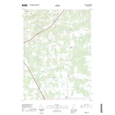
2023 Map of Gageville
USGS Topo · Published 2023About this map
The Ashtabula River carves a winding path through the northern landscape of this Ashtabula County survey, creating a terrain characterized by steep river bluffs and deep creek valleys. Settlement patterns are focused around historic centers like Gageville and Sheffield Center, where local history is anchored by the Gageville Cem. Further south, the map details the rural hamlets of Bulah and Denmark Center, alongside the aviation infrastructure of the Northeast Ohio Regional Airport.
Find a feature on this map
67 named features on this map. Tap any name to fly to it.
Don’t see what you’re looking for? This feature index may not catch every label — zoom into the map to look around manually.
Map Details
Editions of this 2023 Gageville Map
This is the sole edition of this map. No revisions or reprints were ever made.
Other maps of this area

1905 · Andover
USGS Topo · 1:48,000

1905 · Ashtabula
USGS Topo · 1:62,500

1905 · Jefferson
USGS Topo · 1:62,500

1906 · Conneaut
USGS Topo · 1:62,500

1907 · Andover
USGS Topo · 1:62,500

1907 · Jefferson
USGS Topo · 1:62,500

1950 · Cleveland
USGS Topo · 1:250,000

1956 · Cleveland
USGS Topo · 1:250,000

1959 · Dorset
USGS Topo · 1:24,000
1959 · Leon
USGS Topo · 1:24,000