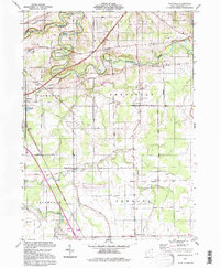
1994 Map of Gageville
USGS Topo · Published 1997About this map
The Ashtabula River carves a deep valley across the northern reaches of this map, its winding course crossed by several Covered Bridges that reflect the preservation of historic infrastructure within the townships of Plymouth and Sheffield. Settlement patterns here follow a grid of family-named roads like Hadlock Road and Stevenson Road, connecting small clusters such as Gageville and Sheffield Center. The landscape is a mix of agricultural plots and wooded drainage basins, centered around the Ashtabula County Airport and localized industry represented by numerous Gas Wells and Gravel Pits. Southward, the terrain levels out into Denmark township, where the small community of Denmark Center sits at a crossroads near Mill Creek. This 1994 photoinspection captures the area just before the turn of the century, showing a stable rural landscape where the quiet hamlet of Bulah and landmarks like St Andrews Ch remain as local anchors.
Find a feature on this map
56 named features on this map. Tap any name to fly to it.
Don’t see what you’re looking for? This feature index may not catch every label — zoom into the map to look around manually.
Map Details
Editions of this 1994 Gageville Map
This is the sole edition of this map. No revisions or reprints were ever made.
Other maps of this area

1905 · Andover
USGS Topo · 1:48,000

1905 · Ashtabula
USGS Topo · 1:62,500

1905 · Jefferson
USGS Topo · 1:62,500

1906 · Conneaut
USGS Topo · 1:62,500

1907 · Andover
USGS Topo · 1:62,500

1907 · Jefferson
USGS Topo · 1:62,500

1950 · Cleveland
USGS Topo · 1:250,000

1956 · Cleveland
USGS Topo · 1:250,000

1959 · Dorset
USGS Topo · 1:24,000
1959 · Leon
USGS Topo · 1:24,000
Featured Places
- Jefferson Township, OH
- Plymouth, Plymouth Township
- Plymouth Township, OH
- Kingsville Township, OH
- Ashtabula Township, OH