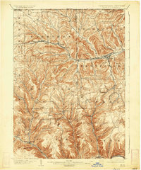
1900 Map of Gaines
USGS Topo · Published 1934About this map
Cowanesque River and Pine Creek valley floors dictate the settlement patterns of this rugged Tioga and Potter County borderland at the turn of the century. The northern half of the landscape is dominated by the New York Central and Hudson River and the Cowanesque Branch, supporting local industry and trade in hubs like Westfield and Harrison Valley. Smaller hamlets like Tannery and Mills highlight the era's reliance on proximity to rail lines and water power.
Find a feature on this map
72 named features on this map. Tap any name to fly to it.
Don’t see what you’re looking for? This feature index may not catch every label — zoom into the map to look around manually.
Map Details
Editions of this 1900 Gaines Map
5 editions found
Other maps of this area

1899 · Gaines
USGS Topo · 1:62,500

1900 · Gaines
USGS Topo · 1:62,500

1900 · Elkland
USGS Topo · 1:62,500

1924 · Woodhull
USGS Topo · 1:48,000

1926 · Wellsville
USGS Topo · 1:62,500

1926 · Woodhull
USGS Topo · 1:62,500

1926 · Greenwood
USGS Topo · 1:62,500

1932 · Genesee
USGS Topo · 1:62,500

1937 · Genesee
USGS Topo · 1:62,500

1944 · Woodhull
USGS Topo · 1:62,500