1943 Map of Gainesville
USGS Topo · Published 1943About this map
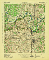
Camp Howze Military Reservation dominates the center of this landscape during the early 1940s, reflecting the massive military expansion in Cooke County and across the state line into Love County. The Red River serves as a winding border between Texas and Oklahoma, characterized by deep loops such as Sivells Bend and Warrens Bend. This period shows a transition from rural agricultural dominance to wartime mobilization, with the Missouri-Kansas-Texas railroad connecting the regional hub of Gainesville to outlying communities like Muenster and Marietta. A dense network of one-room schoolhouses, including Whaley Chapel School and Wolf Ridge School, illustrates the social fabric of the era. The presence of Thompson Ferry and various river crossings highlights the importance of the river as both a barrier and a thoroughfare for the settlements of Coesfield and Burneyville.
Find a feature on this map
89 named features on this map. Tap any name to fly to it.
Don’t see what you’re looking for? This feature index may not catch every label — zoom into the map to look around manually.
Map Details
Editions of this 1943 Gainesville Map
This is the sole edition of this map. No revisions or reprints were ever made.
Other maps of this area

1901 · Addington
USGS Topo · 1:125,000

1901 · Tishomingo
USGS Topo · 1:125,000

1901 · Ardmore
USGS Topo · 1:125,000

1901 · Denison
USGS Topo · 1:125,000

1902 · Gainesville
USGS Topo · 1:125,000

1905 · Montague
USGS Topo · 1:125,000

1918 · Ardmore
USGS Topo · 1:125,000

1954 · Sherman
USGS Topo · 1:250,000

1957 · Ardmore
USGS Topo · 1:250,000
1958 · Gordonville
USGS Topo · 1:62,500