
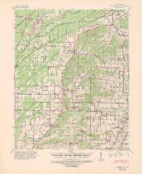
1940 Map of Gainesville
USGS Topo · Published 1942About this map
Crowley Ridge bisects this landscape, separating the intricate drainage network of the Cache River lowlands from the higher ground near Paragould. In the years leading up to the war, this section of Northeast Arkansas was a dense grid of rural schools and small churches, such as Croft Academy, Evening Star Sch, and Warren Chapel & Cem. The map reveals the extensive engineering required to manage the wetlands, shown through a system of numbered laterals and major cuts like Big Canal and Petersburg Ditch. These drainage projects allowed for the expansion of settlements like Delaplaine and Beech Grove along the St Louis Southwestern Ry. On the ridge itself, Crowley Ridge State Park appears near Walcott, while several cemeteries like Linwood Cem and Finch Cem provide vital clues for family historians tracing early residents in Greene County.
Find a feature on this map
121 named features on this map. Tap any name to fly to it.
Don’t see what you’re looking for? This feature index may not catch every label — zoom into the map to look around manually.
Map Details
Editions of this 1940 Gainesville Map
2 editions found
Other maps of this area

1932 · Walnut Ridge
USGS Topo · 1:62,500

1935 · Sedgwick
USGS Topo · 1:62,500

1935 · Rector
USGS Topo · 1:62,500

1935 · Knobel
USGS Topo · 1:62,500

1935 · Reyno
USGS Topo · 1:62,500

1935 · Walnut Ridge
USGS Topo · 1:62,500

1939 · Jonesboro
USGS Topo · 1:62,500

1940 · Marmaduke
USGS Topo · 1:62,500

1941 · Leachville
USGS Topo · 1:62,500

1941 · Knobel
USGS Topo · 1:62,500