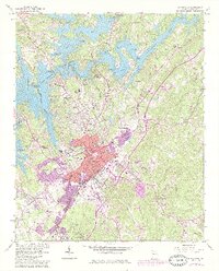
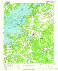
1964 Map of Gainesville
USGS Topo · Published 1986About this map
Gainesville serves as the focal point of this Hall County survey, which documents the city's relationship with the Chattahoochee River and the expanding shoreline of Lake Sidney Lanier. The map illustrates a landscape shaped by education and industry, featuring prominent institutions such as Brenau College, Riverside Academy, and the Gainesville Mill. Beyond the central district, industrial and residential satellite communities like New Holland and Chicopee are clearly defined alongside the Southern railroad line. The expansion of suburban developments such as Lakeshore Estates and Morningside Hills highlights the mid-century growth patterns of the region. Extensive shoreline details, including the Thompson Bridge Access Point and Longstreet Bridge, show the transformation of the river valley into a major recreational hub following the creation of the reservoir.
Find a feature on this map
88 named features on this map. Tap any name to fly to it.
Don’t see what you’re looking for? This feature index may not catch every label — zoom into the map to look around manually.
Map Details
Editions of this 1964 Gainesville Map
4 editions found
Other maps of this area

1891 · Gainesville
USGS Topo · 1:125,000

1954 · Greenville
USGS Topo · 1:250,000

1958 · Greenville
USGS Topo · 1:250,000

1964 · Murrayville
USGS Topo · 1:24,000

1964 · Chestnut Mountain
USGS Topo · 1:24,000

1964 · Lula
USGS Topo · 1:24,000

1964 · Gainesville
USGS Topo · 1:24,000
1964 · Chestatee
USGS Topo · 1:24,000

1964 · Pendergrass
USGS Topo · 1:24,000
1964 · Flowery Branch
USGS Topo · 1:24,000