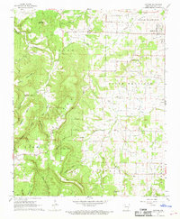
1967 Map of Gaither
USGS Topo · Published 1968About this map
Gaither Mountain dominates the central topography of this Boone County landscape, creating a high-relief divide between the many hollows and coves to the west and the more settled drainage of West Fork Crooked Creek to the east. In the late 1960s, small crossroads communities like Capps, Grubb Springs, and Gaither served as local anchors for rural residents and farmers. The map reveals a deeply established social fabric through its numerous burial grounds, including Coker Cem, Robinson Cem, and Wagley Cem, alongside local institutions such as Plumly Sch and Valley View Ch. The western edge of the mountain is carved by distinctive topographic features like Fernsides Cove and Terrapin Cove, while the eastern side shows evidence of infrastructure including a Landing Strip and multiple Radio Towers, reflecting the mid-century integration of telecommunications into the Ozark highlands.
Find a feature on this map
45 named features on this map. Tap any name to fly to it.
Don’t see what you’re looking for? This feature index may not catch every label — zoom into the map to look around manually.
Map Details
Editions of this 1967 Gaither Map
2 editions found
Other maps of this area

1904 · Harrison
USGS Topo · 1:125,000

1905 · Harrison
USGS Topo · 1:125,000

1945 · Harrison
USGS Topo · 1:250,000

1949 · Harrison
USGS Topo · 1:250,000

1954 · Harrison
USGS Topo · 1:250,000

1958 · Harrison
USGS Topo · 1:250,000

1964 · Harrison
USGS Topo · 1:250,000
1967 · Gaither
USGS Topo · 1:24,000
1967 · Bergman
USGS Topo · 1:24,000
1967 · Jasper
USGS Topo · 1:24,000