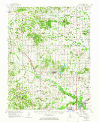
1963 Map of Galatia
USGS Topo · Published 1966About this map
Galatia and Harrisburg anchor this mid-century topographic portrait of Southern Illinois, where the agricultural landscape is deeply marked by the extractive industries and transportation networks of the 1960s. The map illustrates a dense web of rural infrastructure, including the Illinois Central Railroad and the Louisville & Nashville Railroad, which served the region's productive coal and oil sectors. Numerous oil wells and the designated Oil Field near Muddy indicate the subterranean activity that fueled local economies alongside traditional farming.
Find a feature on this map
122 named features on this map. Tap any name to fly to it.
Don’t see what you’re looking for? This feature index may not catch every label — zoom into the map to look around manually.
Map Details
Editions of this 1963 Galatia Map
2 editions found
Other maps of this area

1905 · Eldorado
USGS Topo · 1:62,500

1906 · Eldorado
USGS Topo · 1:62,500

1908 · Galatia
USGS Topo · 1:62,500

1909 · West Frankfort
USGS Topo · 1:62,500

1916 · Equality
USGS Topo · 1:62,500

1925 · Marion
USGS Topo · 1:62,500

1925 · Harrisburg
USGS Topo · 1:62,500

1938 · Galatia
USGS Topo · 1:62,500

1939 · Ina
USGS Topo · 1:62,500

1939 · Harrisburg
USGS Topo · 1:62,500