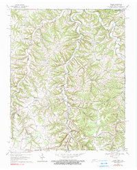
1969 Map of Galen
USGS Topo · Published 1990About this map
The borderlands of Macon County, Tennessee, and Monroe County, Kentucky, are defined by the winding course of Salt Lick Creek and Long Fork in this 1969 field-checked survey. Small rural settlements like Galen, Webbtown, and Bugtussle anchor the landscape, which is marked by a network of country churches including White Oak Ch and Antioch Ch. Local genealogy is preserved in family-named landmarks such as Scott Cem and Cook Cem, while the presence of several Gas Wells and Drill Holes scattered across the ridges points to the mid-century extraction efforts in the region. The map captures the quiet, dispersed nature of these upland communities just before modern development began to alter the remote valleys like Grisham Hollow and Brooks Hollow.
Find a feature on this map
43 named features on this map. Tap any name to fly to it.
Don’t see what you’re looking for? This feature index may not catch every label — zoom into the map to look around manually.
Map Details
Editions of this 1969 Galen Map
2 editions found
Other maps of this area

1931 · Lafayette
USGS Topo · 1:62,500

1931 · Red Boiling Springs
USGS Topo · 1:62,500

1932 · Carthage
USGS Topo · 1:62,500

1954 · Fountain Run
USGS Topo · 1:24,000

1954 · Gamaliel
USGS Topo · 1:24,000

1954 · Holland
USGS Topo · 1:24,000

1956 · Corbin
USGS Topo · 1:250,000

1956 · Nashville
USGS Topo · 1:250,000

1958 · Corbin
USGS Topo · 1:250,000
1958 · Lafayette
USGS Topo · 1:24,000