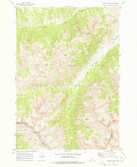
1970 Map of Galena Peak
USGS Topo · Published 1978About this map
Boulder Mountains topography dominates this high-altitude survey of the central Idaho wilderness. At the headwaters of the East Fork Salmon River, the map captures a landscape defined by seasonal water flow and mineral prospecting. Evidence of early extractive industry is visible near the Custer Co Blaine Co boundary, where several Mines are located on the slopes below Galena Peak. The area is interlaced with a network of Pack Trails and Jeep Trails, indicating a period when access to these remote heights was limited to rugged vehicles and livestock. Notable drainage systems like Germania Creek and Washington Creek feed into the Salmon River system, while Washington Lake sits as a significant alpine feature in the northwest corner. This mapping effort, field-checked in 1970, provides a detailed view of the Sawtooth National Recreation Area before more modern infrastructure changes reached these peaks.
Find a feature on this map
24 named features on this map. Tap any name to fly to it.
Don’t see what you’re looking for? This feature index may not catch every label — zoom into the map to look around manually.
Map Details
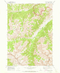
Editions of this 1970 Galena Peak Map
2 editions found
Other maps of this area

1895 · Hailey
USGS Topo · 1:125,000

1897 · Hailey
USGS Topo · 1:125,000

1900 · Sawtooth
USGS Topo · 1:125,000

1919 · Custer
USGS Topo · 1:125,000

1922 · Custer
USGS Topo · 1:125,000

1929 · Bayhorse
USGS Topo · 1:125,000

1955 · Hailey
USGS Topo · 1:250,000

1957 · Challis
USGS Topo · 1:250,000

1959 · Hailey
USGS Topo · 1:250,000

1960 · Challis
USGS Topo · 1:250,000