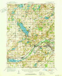
1950 Map of Galesburg
USGS Topo · Published 1950About this map
Gull Lake dominates the northern landscape of this 1950 edition, surrounded by summer settlements like Woodlawn Beach and Poplar Beach. The southwestern corner is anchored by the industrial and transport hub of Galesburg, where the Michigan Central railroad follows the valley of the Kalamazoo River. This waterway connects the region's early milling history at Howlandsburg and Augusta to the emerging post-war expansion.
Find a feature on this map
133 named features on this map. Tap any name to fly to it.
Don’t see what you’re looking for? This feature index may not catch every label — zoom into the map to look around manually.
Map Details
Editions of this 1950 Galesburg Map
2 editions found

Other maps of this area

1916 · Kalamazoo
USGS Topo · 1:62,500

1918 · Kalamazoo
USGS Topo · 1:62,500

1918 · Battle Creek
USGS Topo · 1:62,500

1918 · Union City
USGS Topo · 1:62,500

1918 · Galesburg
USGS Topo · 1:62,500

1918 · Leonidas
USGS Topo · 1:62,500

1922 · Schoolcraft
USGS Topo · 1:62,500

1943 · Battle Creek
USGS Topo · 1:62,500

1943 · Kalamazoo
USGS Topo · 1:62,500

1943 · Schoolcraft
USGS Topo · 1:62,500