
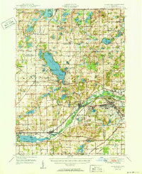
1950 Map of Galesburg
USGS Topo · Published 1950About this map
Fort Custer Military Reservation dominates the southeastern quadrant of this landscape, showing a dense network of specialized infrastructure including the Post Hospital and Veterans Administration Hospital. Just west of the military grounds, the town of Augusta sits at the junction of the Michigan Central railroad and the river, while Galesburg serves as a major hub further downstream. The map reveals a transition from these industrial and military corridors to the recreational and agricultural lands surrounding Gull Lake.
Find a feature on this map
119 named features on this map. Tap any name to fly to it.
Don’t see what you’re looking for? This feature index may not catch every label — zoom into the map to look around manually.
Map Details
Editions of this 1950 Galesburg Map
2 editions found
Other maps of this area

1916 · Kalamazoo
USGS Topo · 1:62,500

1918 · Kalamazoo
USGS Topo · 1:62,500

1918 · Battle Creek
USGS Topo · 1:62,500

1918 · Union City
USGS Topo · 1:62,500

1918 · Galesburg
USGS Topo · 1:62,500

1918 · Leonidas
USGS Topo · 1:62,500

1922 · Schoolcraft
USGS Topo · 1:62,500

1943 · Battle Creek
USGS Topo · 1:62,500

1943 · Kalamazoo
USGS Topo · 1:62,500

1943 · Schoolcraft
USGS Topo · 1:62,500