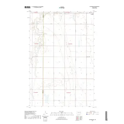
2018 Map of Galesburg NW
USGS Topo · Published 2018About this map
Portland sits at the northeastern edge of this prairie landscape, where the agricultural grid is defined by the Steele Co Traill Co boundary line. This 2018 survey reveals a terrain shaped by water management and transit, centered on the S Br Goose River and the complex drainage network of Roseville Drain Number 19. The settlement of Roseville serves as a local landmark along the county road system, while the presence of Bruflat Cem near the town of Portland offers a specific point of interest for those researching local family history. The map illustrates how section lines and county highways like Co Hwy 11 and Co Hwy 20 organize the flat, productive Red River Valley region.
Find a feature on this map
28 named features on this map. Tap any name to fly to it.
Don’t see what you’re looking for? This feature index may not catch every label — zoom into the map to look around manually.
Map Details
Editions of this 2018 Galesburg NW Map
This is the sole edition of this map. No revisions or reprints were ever made.
Other maps of this area

1952 · Grand Forks
USGS Topo · 1:250,000

1956 · Grand Forks
USGS Topo · 1:250,000

1966 · Grand Forks
USGS Topo · 1:250,000

1966 · Galesburg
USGS Topo · 1:24,000

1966 · Hope SE
USGS Topo · 1:24,000

1967 · Mayville South
USGS Topo · 1:24,000

1968 · Hope NE
USGS Topo · 1:24,000
1968 · Galesburg
USGS Topo · 1:24,000
1968 · Galesburg NW
USGS Topo · 1:24,000
1968 · Galesburg SE
USGS Topo · 1:24,000