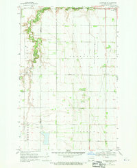
1968 Map of Galesburg
USGS Topo · Published 1970About this map
The South Branch Goose River and Goose River snake through the flat agricultural townships of Enger, Primrose, and Roseville along the Steele and Traill County line. This late-1960s landscape is defined by its drainage and transport patterns, from the Roseville Drain No 19 to the Old Railroad Grade that runs north through the small settlement of Roseville. Evidence of the area's social and industrial history is sparse but clear, featuring Trinity Ch and several scattered Gravel Pit operations. In the northeastern corner, the edge of Portland appears near the Bruflat Cem, while a lone Radio Tower marks the open plains between the river branches and the railroad line.
Find a feature on this map
16 named features on this map. Tap any name to fly to it.
Don’t see what you’re looking for? This feature index may not catch every label — zoom into the map to look around manually.
Map Details
Editions of this 1968 Galesburg Map
This is the sole edition of this map. No revisions or reprints were ever made.
Other maps of this area

1952 · Grand Forks
USGS Topo · 1:250,000

1956 · Grand Forks
USGS Topo · 1:250,000

1966 · Grand Forks
USGS Topo · 1:250,000

1966 · Galesburg
USGS Topo · 1:24,000

1966 · Hope SE
USGS Topo · 1:24,000

1967 · Mayville South
USGS Topo · 1:24,000

1967 · Ayr NE
USGS Topo · 1:24,000

1967 · Ayr NW
USGS Topo · 1:24,000

1967 · Page
USGS Topo · 1:24,000

1968 · Hope NE
USGS Topo · 1:24,000