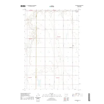
2020 Map of Galesburg NW
USGS Topo · Published 2020About this map
Portland anchors the northern boundary of this agricultural landscape in eastern North Dakota, situated where the Steele Co Traill Co line defines the western edge of the township. The terrain is characterized by the meandering path of the S Br Goose River as it cuts through the western sections, contrasted by the engineered precision of the Roseville Drain Number 19 to the east. Near the settlement of Roseville, the Trinity Lutheran Church Cem serves as a significant local landmark for genealogical research, marking a central point of community history amidst the gridded road network of Co Hwy 11 and Co Hwy 16. The map illustrates the late-twentieth-century rural infrastructure, where section lines are strictly maintained by local routes like 147th Ave NE and 5th St NE, supporting the region's enduring farming legacy.
Find a feature on this map
29 named features on this map. Tap any name to fly to it.
Don’t see what you’re looking for? This feature index may not catch every label — zoom into the map to look around manually.
Map Details
Editions of this 2020 Galesburg NW Map
This is the sole edition of this map. No revisions or reprints were ever made.
Other maps of this area

1952 · Grand Forks
USGS Topo · 1:250,000

1956 · Grand Forks
USGS Topo · 1:250,000

1966 · Grand Forks
USGS Topo · 1:250,000

1966 · Galesburg
USGS Topo · 1:24,000

1966 · Hope SE
USGS Topo · 1:24,000

1967 · Mayville South
USGS Topo · 1:24,000

1968 · Hope NE
USGS Topo · 1:24,000
1968 · Galesburg
USGS Topo · 1:24,000
1968 · Galesburg NW
USGS Topo · 1:24,000
1968 · Galesburg SE
USGS Topo · 1:24,000