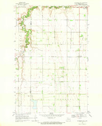
1968 Map of Galesburg NW
USGS Topo · Published 1970About this map
The Goose River and its South Branch Goose River carve a meandering path through the northwestern corner of Traill County, defining the agricultural landscape of Roseville and Norman townships. During this era of late 1960s photogrammetric mapping, the region's rural character is anchored by small settlements and communal landmarks, such as Portland at the northeastern edge and the Trinity Ch near the village of Roseville. Evidence of shifting transportation priorities is clearly marked by the Old Railroad Grade running north-south through the eastern sections, a vestige of the rail network that once supported the local grain economy. The map reveals the intricate water management of the Red River Valley, including the Roseville Drain No 19, which serves the low-lying prairie between the river's edge and the county line shared with Steele County.
Find a feature on this map
16 named features on this map. Tap any name to fly to it.
Don’t see what you’re looking for? This feature index may not catch every label — zoom into the map to look around manually.
Map Details
Editions of this 1968 Galesburg NW Map
This is the sole edition of this map. No revisions or reprints were ever made.
Other maps of this area

1952 · Grand Forks
USGS Topo · 1:250,000

1956 · Grand Forks
USGS Topo · 1:250,000

1966 · Grand Forks
USGS Topo · 1:250,000

1966 · Galesburg
USGS Topo · 1:24,000

1966 · Hope SE
USGS Topo · 1:24,000

1967 · Mayville South
USGS Topo · 1:24,000

1968 · Hope NE
USGS Topo · 1:24,000
1968 · Galesburg
USGS Topo · 1:24,000
1968 · Galesburg SE
USGS Topo · 1:24,000
1970 · Northwood SE
USGS Topo · 1:24,000