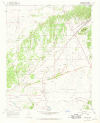
1966 Map of Galisteo
USGS Topo · Published 1970About this map
The settlement of Galisteo anchors this high-desert landscape in the mid-1960s, situated where the Atchison Topeka and Santa Fe railroad tracks traverse a terrain of arroyos and cañadas. The map captures the industrial and agricultural infrastructure of the era, from the Quarry near Cerro Colorado to scattered landmarks like Thornton Ranch and McKee Ranch. Evidence of much older habitation is marked by the Pueblo los Tanos Ruins, providing a glimpse into the region's long history before the arrival of the railroad junctions at Spiess and Kennedy. Water management is central to life here, as seen in the numerous labels for the School House Windmill, Galisteo Well, and the seasonal Galisteo Lake. This survey illustrates how the rugged geography of San Cristoval and the Galisteo Creek drainage dictated the placement of early 20th-century transportation and ranching outposts.
Find a feature on this map
38 named features on this map. Tap any name to fly to it.
Don’t see what you’re looking for? This feature index may not catch every label — zoom into the map to look around manually.
Map Details
Editions of this 1966 Galisteo Map
2 editions found
Other maps of this area

1889 · Santa Fe
USGS Topo · 1:125,000

1892 · San Pedro
USGS Topo · 1:125,000

1892 · Santa Clara
USGS Topo · 1:125,000

1894 · Santa Fe
USGS Topo · 1:125,000

1894 · Lamy
USGS Topo · 1:125,000

1951 · Turquoise Hill
USGS Topo · 1:24,000

1952 · Turquoise Hill
USGS Topo · 1:24,000

1952 · Seton Village
USGS Topo · 1:24,000

1953 · Glorieta
USGS Topo · 1:24,000

1953 · Agua Fria
USGS Topo · 1:62,500