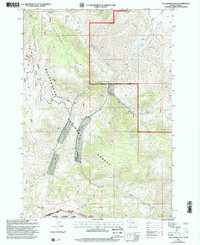
1997 Map of Gallagher Gulch
USGS Topo · Published 2002About this map
The Continental Divide defines the southwestern boundary of this high-altitude landscape, marking the rugged transition between the Beaverhead National Forest in Montana and the Targhee National Forest in Idaho. The terrain is characterized by the massive spine of the Beaverhead Mountains and White Pine Ridge, where numerous seasonal and year-round water sources like White Pine Spring and Seybold Spring sustain the local ecology. Evidence of historical extraction is scattered across the slopes, with several noted Prospects and Mines indicating the area's prospecting legacy. The drainage network is dominated by Little Sheep Creek and its various forks, while the Scenic Trail provides a route through the backcountry near East Creek Campground. This 1997 revision captures the primitive character of the borderlands, where the administrative lines of the Dillon Ranger District meet the physical reality of the divide.
Find a feature on this map
36 named features on this map. Tap any name to fly to it.
Don’t see what you’re looking for? This feature index may not catch every label — zoom into the map to look around manually.
Map Details
Editions of this 1997 Gallagher Gulch Map
This is the sole edition of this map. No revisions or reprints were ever made.
Other maps of this area

1955 · Dubois
USGS Topo · 1:250,000

1957 · Scott Peak
USGS Topo · 1:62,500

1957 · Edie Ranch
USGS Topo · 1:62,500

1958 · Dubois
USGS Topo · 1:250,000

1965 · Caboose Canyon
USGS Topo · 1:24,000

1965 · Gallagher Gulch
USGS Topo · 1:24,000

1965 · Lima
USGS Topo · 1:24,000

1965 · Dixon Mountain
USGS Topo · 1:24,000

1965 · Dell
USGS Topo · 1:24,000

1965 · Lima Peaks
USGS Topo · 1:24,000