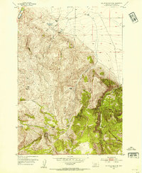
1952 Map of Gallagher Mountain
USGS Topo · Published 1954About this map
Flynn Brothers Ranch and Stefonic Ranch anchor the northern landscape of this Beaverhead County region, where high-altitude ranching and water management define the topography. The presence of Lovells Lake (Warm Spring Area) and several remote homesteads, including Hawkins Ranch and Crampton Ranch, suggests a mid-century economy built on livestock and seasonal grazing.
Find a feature on this map
29 named features on this map. Tap any name to fly to it.
Don’t see what you’re looking for? This feature index may not catch every label — zoom into the map to look around manually.
Map Details
Editions of this 1952 Gallagher Mountain Map
2 editions found
Other maps of this area

1893 · Dillon
USGS Topo · 1:250,000

1952 · Burns Mountain
USGS Topo · 1:24,000

1952 · Dalys
USGS Topo · 1:24,000

1952 · Gallagher Mountain
USGS Topo · 1:24,000

1955 · Dubois
USGS Topo · 1:250,000

1955 · Dillon
USGS Topo · 1:250,000

1957 · Dillon
USGS Topo · 1:250,000

1958 · Dubois
USGS Topo · 1:250,000

1958 · Dillon
USGS Topo · 1:250,000

1961 · Ashbough Canyon
USGS Topo · 1:24,000